Seismicity of Nagpur and adjoining areas
| Date :26-Dec-2024 |

By Dr Anjan Chatterjee :
Nagpur district lies in an area classified in the Zone-II (BIS Seismic Map of India, 2002), which is supposed to be the safest zone. The Zones I and II are being clubbed together, lately. In the older BIS map, Nagpur was located in Zone-I, implying that the locality was the least active seismically.
Nagpur has always been sensing tremors from earthquakes emanating from a few near and distant epicenters that have been recorded, creating panic. The area has experienced mild tremors from earthquakes originating from nearby active Son-Narmada-Tapti Fault (SNTF). The maximum seismic intensity experienced in Nagpur and its neighbourhood was a result of the Satpura earthquake of March 14, 1938 with a magnitude of 6.3 with its epicentre at Gawligarh in Amravati district. Quite a few civil structures in Nagpur developed mild cracks as a result.
Besides, the other noteworthy earthquakes due to which tremors were experienced in Nagpur and its surrounding areas are the Koyna earthquake of December 10, 1967 (magnitude 6.5), Bhadrachlam earthquake on April 13, 1969 (magnitude 5.3), and the earthquake during dawn on September 30, 1993 of moderate intensity (magnitude 6.3), with epicentre in Latur district. The Bhuj earthquake at 8.46 am on January 26, 2001 of 7.7 magnitude, killing about 20,000 people was sensed faintly at Nagpur, but more devastatingly in near locations like Rajkot, Gandhinagar, and Ahmedabad, with tremors felt at some far-off locations like Kolkata, as it is located over alluvial soil and on clay sediments.
Nagpur has sensed very recent tremors owing to seismic activities with epicenters in the vicinity in places like Seoni (2021-2024), Hingoli and northeast of Hingoli (2024), and Mulugu (2024). Since Nagpur has no known seismic history of its own due to absence of active faults traversing the city, it shall however be sensing tremors owing to seismic activities in its vicinity due to known, existing active faults like the SNTF and the Godavari fault.
Nagpur is just about 150 kms from the nearest locality falling in the vulnerable SNTF’s fault line viz. areas around Gawligarh in Amravati district. A tremor from Amravati district on January 21, 2012, with magnitude 2.3 with location 139 kms away from Nagpur, north-east of Amravati had been recorded in Broadband Seismic (BBS) Observatory of the Geological Survey of India (GSI). Many such tremors are recorded in the vicinity of the areas falling in the SNTF, around Jabalpur.
The SNTF stretches from Shahdol/Umaria/ Katni districts to its east, further westward upto Burhanpur and Jalgaon via Amravati district and north of Akola. The SNTF is tectonically more active in the Jabalpur-Amravati-Khandwa/Khargone districts.
The devastating Jabalpur earthquake of May 22, 1997 with its 5.8 magnitude, was triggered by the SNTF reactivation. Jabalpur has had a history of earthquakes recorded since 1846. The SNTF is active and its activity is directly related to the Himalayan orogeny, being a sympathetic fault to the Main Boundary Thrust (MBT) that occurs along the base of the Himalayan range.
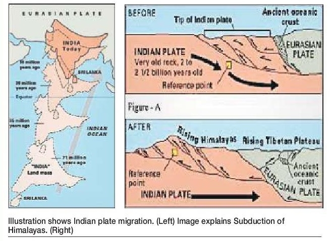
The Himalayan mountain chain was formed as a result of the collision of the Indian plate with the Eurasian plate (see image). Owing to the plate movements, the Indian plate had commenced moving north-eastwards about 71 million years ago, separating from the African continent. Driven by the plate collision about 10 million years ago, the Indian plate subducted under the Eurasian plate forming the Himalayan range (see another image). Tibet and China are located further north-east within the Eurasian plate. The Himalayan range stretching across 2,900 kms was formed and at its base lies the MBT, an active fault.
The movement of the Indian plate still continues till this day at the rate of about 5 cms north-easterly, per year. Such an uninterrupted north-easterly plate movement is the main causative factor for triggering earthquakes in most localities in India. Most of the active faults in India are sympathetic to the MBT, including the SNTF. Nearly all the localities in the foothills of the Himalayan range fall in Zone-V.
GSI active fault mapping programme envisaged mapping of strips alongside the Son-Narmada-Purna-Tapti rivers, right from Shahdol district (Madhya Pradesh) till Jalgaon (Maharashtra) district covering all localities falling on these river stretches.
A total area of nearly 1,200 sq kms of the newer Quaternary sediments (age 2.58 million years old till present day) were studied by the teams of GSI for traces and existence of neotectonism and active faults. At many locations, evidences of active faults have been duly established by the GSI, proving that the SNTF is still quite active till this day.
Since Nagpur has no seismic history, we must not have a laid-back approach. Latur district has had no history of earthquake ever, but the 1993 earthquake occurred owing to reactivation of a deep-seated fault baffling the seismologists. Hence, preparedness for eventualities is always desired.
(The author is former Director, Earthquake Geology Division, GSI, Central Region and later Additional Director General, GSI)


