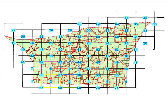
Cadastral maps transforming into 1:500 scale in CG
| Date :28-Nov-2020 |

By Abhishek Kumar
In a bid to provide large scale maps of lands for the purpose of land sale and purchase in major towns of State, Chhattisgarh Council of Science and Technology (CCOST) in collaboration with Revenue Department, Government is transforming cadastral map of urban areas into 1:500 scale.
Speaking to The Hitavada, senior scientist of the CCOST M K Beg said that Revenue Department has taken a decision to transform 600 cadastral sheets of urban areas which are available on 1:4000 scale.
Small plots upto 5 decimal, which are not visible on 1:4000 scale map, can be easily indentified on the transformed cadastral maps (1:500 scale).
The process in transforming cadastral maps include indexing, coding, scanning, tiling map with grid, digitisation, linking attribute (parcel numbers), validation, geo-referencing by ortho-rectified imagery, edge matching, enlargement into 500 scale, flagging of GIS data and map for spatial and attribute mismatch with records. Once data of the above said aspect is ready, composition of cadastral maps will be done on 1:500 scale.
One cadastral map will be converted into approximately 25 to 30 sheets, in which full parcel (khasra) will be shown by continuous line and a separate sheet number will be given which will represent as one sheet of 1:500 scale, said Beg.
Verification of each parcel is being done by the CCOST in presence of the concerned Patwaris. Linkage of right of records information is being also done in presence of the patwaris, he added.
The senior scientist of the CCOST further said that the large scale maps 1:500 scale will be useful for land sale and purchase and it will be helpful in resolving land disputes. Transformation of cadastral maps of the major towns like Raipur, Bilaspur, Durg, Bhilai, Korba, Rajnandgaon, Jagdalpur, Ambikapur, Kabirdham and other towns of the state are being prepared.
The government and private agencies can utilize large scale cadastral maps for development works in a planned way. The cadastral map of village contains arranged information on all parcel/Khasra/survey numbers falling in particular village.
Cadastral maps are one of requisite documents for the district administration in dealing with day to day revenue related issues and development activities of villages. Most of the government departments are using these cadastral maps for their new upcoming projects. In many cases, these maps have lost their relevance since the maps are not updated over a long time and not matching with modern technology surveyed data. Therefore, updating the cadastral information is very essential so that transformation, changes of ownership, size etc. can be recorded in satellite data based cadastral system throughout the country.